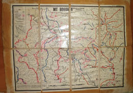
One of my first maps of the high country is of the Bogong High Plains. I cut the map into segments, laminated it, and pasted it onto cloth. There were no fold marks on the map. However, I discovered that bearings do not work very well when the map is in bits. Nice try! Note the coloured roads and rivers; these days all maps have colour. There were no grids and no contours.
Maps must be in a waterproof case. There are several such cases designed for this purposes, with many having a strap to hang around the neck. This arrangement is good in that the map is unlikely to be lost, the map is always available, and both hands are free. The downside is that with a map, compass, camera and perhaps other items around the neck it gets crowded, with strangulation a possibility - probably undesirable.
I’ve always had maps in two strong plastic bags. Mostly the map is either in my pack or stuffed in my shirt, as I work off terrain, the compass, a watch or a combination. Climb the spur, follow the ridge, bearing 140 degrees magnetic for 50 minutes. A map is not needed for that. Looking at a map too much can be counterproductive and slows progress.
For a while I laminated maps. The sheer bulk of a laminated map, the difficulty of folding it, the breaks at folds - especially where two folds cross - and the cost led to me abandoning lamination.
Sometimes the contours are so close together it’s quite hard to see which contour is what height. To get around this, at home I put small black dots on 100 metre contours, with some heights labelled - 1200, 1400, 1600, etc. This allows me to very easily see the height. Similarly, some maps have the grid numbers on the map edges and not in the middle. To get make it easier to read grid references I write grid numbers on the map every 10-20 grids.
When a long trip requires several maps I invariably make a plan of the maps, allowing me to see where the maps are in relation to each other. This may be based on a
photocopy of a map that covers the entire trip. Areas with only 1:25 000 maps need a lot of maps.
A secondary purpose of a map covering the entire area is to allow you to go outside the proposed route. If your maps cover only the route then you could be in strife. I was on a walk when a party member was injured. I checked the maps. It took a while but I worked out that by walking off the map I could reach a phone. This was done, with the rescue started several hours earlier than had the walk proceeded that morning on the intended route. If I had a map of the surrounding areas I could have reached a phone ten hours before. Lesson learned.
Some trips need just a small sojourn on adjacent maps. Rather than carry this map I copy the section concerned, usually a corner. It’s important to have two sets of maps in the party. If the one set is lost then there will be challenges.
I keep detailed track notes of the more obscure places, written up each evening. Sometimes the time stamp on photos can assist with placing where you are. Mostly I don’t bother keeping track notes as I like each trip to be fresh and I have a good memory. Also, when walking in scrub, there is no certainty that the next trip will be in the same place.
Maps have come a long way since the first explorers ventured there. Some mountains and places have moved on the map, or been renamed, like Mueller Pass, the former name of Albina Pass. Roads and tracks have gone, such as the Strawberry Hill Fire Trail south of Jagungal. If you look closely you can still see parts of it. Old maps can be fascinating from an historical point of view. Be grateful that you have a modern map, and most probably technology.