Show all
{{{description}}}
What is the Jatbula Trail?The Jatbula Trail is an epic 62 kilometre hike that traverses Nitmiluk National Park up in the top end of Australia’s Northern Territory. This is one of Australia’s best hikes, featuring magnificent waterfalls tumbling from high quartzite cliffs, shady monsoon forests, and stunning Jawoyn Aboriginal rock art. The Jatbula Trail takes you up onto the Arnhem Land Escarpment, where you set up camp each day at spectacular waterholes, with no saltwater crocodiles. Small numbers and a set itinerary make this more of a complete hiking “experience” to be enjoyed rather than a race to the end. Take your time and soak in the area – this is one hike that you’re going to want to draw out and savour. I call this “holiday hiking”, and it’s fantastic.
Zandy and I hiked this trail in June 2021 and fell absolutely in love with it. Since we moved to the Northern Territory in 2019, we had heard rave reviews about the Jatbula, and after finishing it, we completely understood what all the fuss was about.
The Jatbula Trail Overview
Location
Nitmiluk National Park, Northern Territory
Length
62 kilometres
Time
5 or 6 days
Season
1 June – 30 September
Type
One-way hiking
Limit
15 people per day
Bookings
Required
Permit cost
$116 or $145 per person (depending on how many nights you choose)
Accommodation
Camping
Start
Nitmiluk Visitor’s Centre at Nitmiluk Gorge/Katherine Gorge
Finish
Leliyn/Edith Falls
Difficulty
Moderate
What to expect
Spectacular waterholes, few people, ancient rock art and the chance to experience an ancient Aboriginal songline
LocationNitmiluk National Park is just outside Katherine, 320 kilometres south of Darwin, the capital of the Northern Territory. We’re talking outback territory here, where the desert meets the tropics. We love this part of the Northern Territory; not only is it beautiful with tons of fun things to do, but it’s also culturally significant, and you can feel the ancient history around you.
CultureOne thing that makes this hike so special is the cultural significance of the trail. Everything about this trail is embedded with the deep spiritual and historical connection for the Jawoyn people, an Australian Aboriginal cultural group, and Nitmiluk National Park's traditional owners.
The Jatbula Trail follows an ancient Jawoyn songline and hunting route. We’re talking ancient – think in the area of tens of thousands of years old. By walking the trail, you follow the footsteps of generations of Jawoyn people who traditionally travelled through parts of this magnificent country.
The trail is named after Peter Jatbula, a Jawoyn elder and traditional owner who was instrumental in securing land rights for his people.
Nitmiluk is a Jawoyn word that translates to “Cicada Place”. The name comes from a dream-time story for the Jawoyn people, and the area is an important place for the Jawoyn. It’s a culturally rich and significant area, and the Jawoyn have graciously allowed the trail to be opened to public use. For this, we couldn’t be more thankful.
The trailThe Jatbula Trail is specifically designed as an experience, and it must be hiked in one direction only, from Nitmiluk Gorge (Katherine Gorge) to Leliyn (Edith Falls). All walkers must follow a set itinerary and camp in a designated campground each night. You cannot stay more than one night in each campground and must move on each day.
“The trail is named after Peter Jatbula, a Jawoyn elder and traditional owner ...
BWA April 2022 | 23

While this may sound off-putting to many independent travellers (and it did to us before we did it), don’t worry about it. It does help build the unique atmosphere of the walk, and we didn’t find it any hassle at all.
You can choose to walk the trail in 5 days (4 nights) or 6 days (5 nights). While the hike is precisely the same with either option, you spend a night at Sweetwater Pool Camp in the more extended version, whereas in the shorter version, you hike on to the end rather than camping at Sweetwater Pool.
One of the best features is that the Jatbula is limited to 15 hikers a day, so you’ll never feel crowded and have plenty of space to enjoy the scenery.
Hiking seasonDue to the extreme heat and the onset of the wet season after October, the Jatbula Trail is usually hiked from 1 June to 30 September. Temperatures can rise to over 40 °C from October to late November, so we think it’s a good idea to follow the recommended guidelines!
The trail is open between 1 October and 31 May. However, you must be experienced, well prepared, and need special permission. You must apply in writing for special permission to jatbula.trail@nt.gov.au.
Due to the unforgiving conditions and risk of flood outside the regular season, we do not recommend undertaking the trail in the off-season.
Best time to walkIn our opinion, the best time to hike the Jatbula is in June. Not only are the temperatures relatively cool, but it’s also the start of the dry season, so the waterholes are all still very full from the previous wet season. It’s remarkable how much they dry up throughout the dry season. Getting in early means the water is fresh and clean, and the heat is significantly less oppressive.
BookingBooking is where things get tricky - the hardest part of the Jatbula is getting a spot in the first place. The Jatbula Trail must be booked, and a note of warning here – this
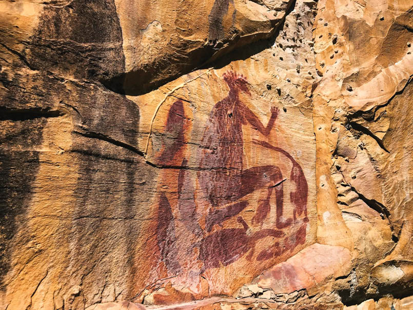
Rock art at the AmphitheatreZandy Marcus
24 | BWA April 2022
hike is extremely popular, which means that it books out very fast. When we booked in 2020, it booked out within one hour! So, to get a spot, you need to be ready at the time bookings open.
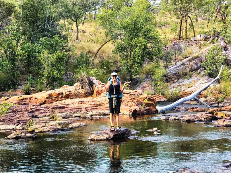
Hiking independentlyThe Jatbula Trail is an easy hike to do independently. It’s very beginner-friendly, and we shared the trail with many first-timers. We encourage all people to give it a go. To hike the trail independently, you simply book via the NT Department of Environment, Parks and Water Security’s online booking system.
When you book, select your date (or any available date!) and then choose either the four or five night option. Once you proceed to pay, wait for the confirmation email to come through; this is how you know it was successful. Make sure you get the confirmation email – we have heard many stories of false-positive bookings.
The NT has recently introduced a new online booking system for the trail.
Hiking in a tour groupHiking as part of a tour group is a very popular way of walking the track. Some people do this to meet other like-minded individuals, feel a sense of security or just because they couldn’t get tickets through the online booking system. Just note that walking in a group tour is much more expensive, $1500 – $2500 per person, if not more.
There are several companies offering group walks.
When we hiked the trail, we met a group from Trek Tours Australia, and everyone on tour raved about the experience. The guides were also very friendly and knowledgeable.
WaitlistIf you aren’t able to get a ticket when bookings open, there is a waitlist, and we know many people that have been able to
get a spot this way. Contact the Nitmiluk National Park Booking Office on 08 8973 8821 and ask to be put on the waitlist. Should a spot become available, the Park office will contact you to let you know.
Cancellations inevitably happen, and vacant spots always pop up, so if you can be flexible, this is another good way to get in.
CancellationsUnfortunately, if you cannot make the hike, Nitmiluk does not issue refunds for cancellations. If you cancel, you forfeit your spot and the amount you paid for your permit.
Transportation – getting there and aroundThere are a few different ways to get to the Jatbula Trail. Most are pretty expensive. However, if you are adventurous, it can be much cheaper. Adventure and affordable – our favourite!
Starting the hikeThe closest major airport is Darwin International Airport, which has regular flights to most capital cities in Australia and some international destinations. From Darwin there are three ways to get to Katherine, 312 kilometres:
fly, daily service;
rent a car; and
take a bus, daily services with Greyhound
One way of getting from Katherine Airport to the Katherine is to organise a taxi with one of the many Katherine taxi companies. It may be worthwhile to book a taxi to avoid waiting times and perhaps to agree upon a rate with the driver.
The track starts at the Nitmiluk Visitor’s Centre at Nitmiluk Gorge, approximately 30 kilometres from the town of Katherine. The easiest way to get to the Jatbula Trail is to drive there by car. Public parking is available at both ends of the trail. If you do not have a car, the first step is to get to Katherine. Katherine has an airport, which is mainly used for smaller, regional flights.
Once you get to Katherine, you can get a taxi to the start of the hike at the Nitmiluk Visitor’s
“It’s very beginner-friendly ...
“ ... if you are adventurous, it can be much cheaper.
BWA April 2022 | 25
Centre (30 kilometres). Alternatively, you can hitchhike (this is the adventurous and affordable part). There are usually many cars going between the two, and it shouldn’t be hard to get a lift.
Finishing the hike
The track starts at Nitmiluk Gorge and ends at Leliyn, so you need to manage this. Leliyn to Katherine is 63 kilometres or approximately 45 minutes drive. Leliyn to Nitmiluk Gorge is 90 kilometres or roughly a one hour drive.
If you have two vehicles, park one at each end and do shuttle runs. Easy and cheap. If you only have one car, there are three ways you can do this:
Park at Nitmiluk Visitor’s Centre, then make your way back from Leliyn when you finish the hike; or
Park at Leliyn and make your way to Nitmiluk Visitor’s Centre on the first day of your hike.
Park at Katherine, go to Nitmiluk Visitor’s Centre.
Whichever you choose, be sure to tell the parks desk or Leliyn kiosk your name, car details and return date.
To get back, you have the following two options.
Shuttle serviceA shuttle service provides transport from Leliyn to either Katherine or Nitmiluk Visitor’s Centre every day. You could arrange this for either before or at the end of your hike (but as the shuttle leaves at 3:00 pm each day, if you want to leave your car at Leliyn you will need to arrange the shuttle the day before your hike starts).
This option is pretty pricey. Leliyn to Katherine is $55 per person and to Nitmiluk is $75 per person. However, there is a minimum car charge of $285, so if it’s only two of you, it will actually cost $142.50 each!
You can arrange the shuttle via Gecko Canoeing and Trekking at either gecko@nttours.com or 0427 067 154.
Hitchhiking
Another option is to leave your car at one end and hitchhike to the other. This is what we did, and it was very easy. (We’re coming back to the theme of adventurous and affordable again).
We left our car at the Nitmiluk Visitor’s Centre at the start of our hike with the intention to hitchhike back at the end. Despite the Leliyn car park being very full, it was a pretty slow start to our hitchhiking attempt. We had many cars drive right past us (some smiling,
The top of 17 Mile FallsDotti Mazga
26 | BWA April 2022
You will need to pack all of your food. Dehydrated meals such as Backcountry Meals are a good choice, if not a bit pricey. We experimented with dehydrating our meals. We also recommend trying instant pasta packages, couscous, and ramen for hiking meals.
As with all hikes in national parks, you must pack out all your rubbish. Carry a few small bags (double bag it just in case of leaks) and carry it with you. We decant as much food as possible before hiking to limit packaging.
Safety
There are emergency call devices at each campsite, so we didn’t feel it was necessary to hike with a personal locator beacon (PLB). As with all hikes in Australia, you should be mindful of snakes and always carry a first-aid kit with a snake bite bandage. The most significant risk on this hike is heat, so as we’ve said, make sure you’re walking early in the day to minimise any risk. Electrolytes are useful.
You must complete a mandatory safety briefing before you even get on the trail. These are held at 8:00 am and 3:00 pm each day. If you take the 7:00 am boat, you must attend the 3:00 pm safety briefing the previous day. If you take the 9:00 am boat, you can choose which one to attend. This is a very comprehensive briefing, going through all the information you need to ensure you’re safe on the trail.
Then, the fun begins!
The trailDay 1: Nitmiluk Gorge to Biddlecombe Cascades, 8.3 km
The hike begins with a boat trip across the Katherine River. This is a 2-3 minute shuttle at two times, 7:00 am and 9:00 am. Do not get your hopes up for any scenic cruise here. This ferry is $15 and must be booked in advance. Be sure to have your permit with you as it will be checked, and it is a condition of entry that you carry it with you at all times.
Once you’re across, you’re officially on the trail, marked by the blue triangles.
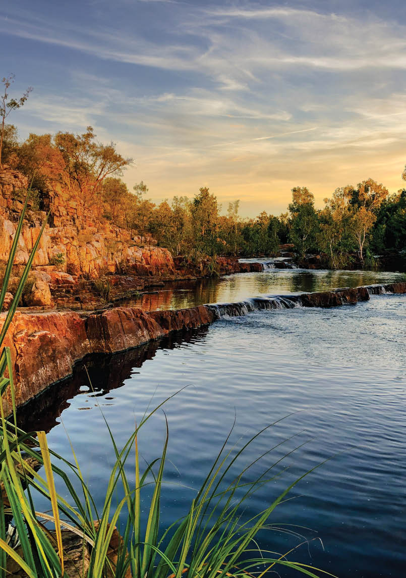
The first four kilometres are flat, easy walking and lead you to Northern Rockhole. This spectacular waterhole has a gushing single drop waterfall in the early dry season (in the later dry season, it has usually slowed to a trickle or stopped altogether).
The waterfall is below the escarpment and can attract saltwater crocodiles during the wet season. When we walked the trail in early June 2021, the area hadn’t been surveyed yet, so it was not deemed safe for swimming – another reason to make sure you pay attention to that safety briefing. Even if you can’t go in the water, it’s an excellent spot for a snack or lunch before continuing to Biddlecombe Cascades.
After leaving Northern Rockhole, you climb up onto the Arnhem Land escarpment, where you will stay for the duration of the trail. Once you reach the top, there are some magnificent views of the park. You should
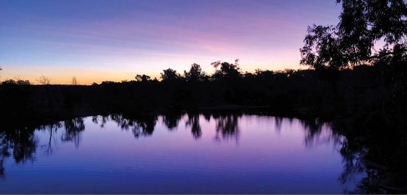
Sun setting over Sweetwater PoolDotti Mazga
28 | BWA April 2022
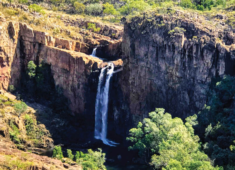

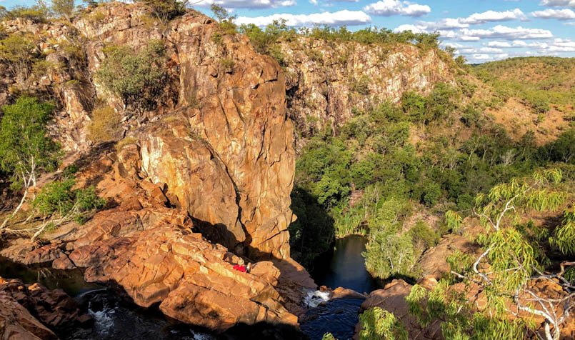
There is a brilliant view of the 17 Mile Falls just before you reach camp. The 17 Mile Falls campground is large, flat and spacious. However, it is the waterhole that steals the show. This was our favourite swimming spot, and we managed to swim to a naturally-formed “seat” at the top of the waterfall that looked out on the entire park. Nature at its best.
We spent too much time on that seat and we both became sunburned a bit. Be sun smart and don’t repeat our mistake.
Day 4: 17 Mile Falls to Sandy Camp,16.8 km
This is the longest day on the entire trail, so to beat the heat, it’s best to leave early.
After 11 kilometres you reach the Edith River, which only very occasionally has water in it. You might be tempted to stop here for a break or a swim, but we highly recommend pushing on instead of taking a break at Channel Waterhole, which is only a short while later, and is much more beautiful, in our opinion.
After a few more kilometres you reach Sandy Camp. The darling camp of the entire trail! It feels like a tropical oasis. True to name, there are sandy banks, and the waterhole is almost a large lake. The camp is set up very well, right on the water's edge with little stone tables constructed.
Sandy Camp also has the honour of hosting a population of freshwater crocodiles. Don’t worry; these guys are relatively harmless. They’re timid creatures and mostly like to be left alone. If you put your head torch on its red setting at night and shine over the water, you may be so lucky to see their eyes reflecting back.
Day 5: Sandy Camp to Sweetwater Pool, 11 km
After Sandy Camp, you follow the Edith River the rest of the way. There are numerous small pools and waterholes along the way. You pass through the monsoon forest before reaching Sweetwater Pool.
Sweetwater Pool is a lovely, large swimming hole (also home to a freshwater crocodile
17 Mile FallsZandy Marcus
30 | BWA April 2022

Dotti and Zandy have embarked on a global journey together, leaving their lives in Australia to wander the globe with no fixed itinerary. While they had a few destinations in mind, they’re really just roaming about and seeing where life takes them. They’ve created Travel Oasis to share their stories, tips and, importantly, highlight what it means to travel in this weird COVID world of ours. They mostly want to show us that travel is possible and inspire us to get out there.
Dotti and Zandy can be found at Travel Oasis, Instagram and Facebook.
This article was originally posted on their blog exploretraveloasis.com/jatbula-trail

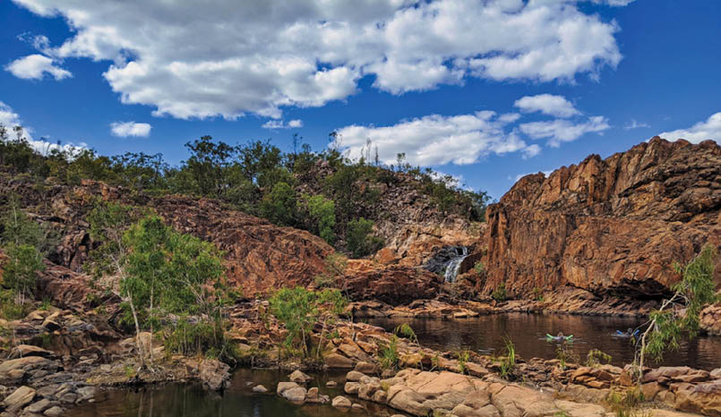
Leliyn/Edith FallsKim Martin
population). It’s a popular day hike from Leliyn (also known as Edith Falls), so it can be quite a shock to be around so many people after the solitude of the past few days. Most day hikers leave by 2-3 pm though, and after that, you’ll be back to the small group of 15.
For those choosing the five day version, you continue to Leliyn from here and finish the same day.
Day 6: Sweetwater Pool to Leliyn, 4.5 km
From here, it’s a very short 4.5 kilometres to the finish. We recommend taking a quick dip at Longhole Swimming Hole before finishing. We also recommend walking to the upper pools of Leliyn. It’s a popular spot, with many people around, but you’ll understand why once there. It’s such a beautiful swimming spot.
Tips and tricks
Download the maps.me map onto your phone. The trail can be hard to follow at times, especially at the start of the season. Having a downloaded map helped us out on a few occasions.
Bring mosquito repellent. The mozzies are pretty full-on.
Always get your water from a fast-flowing source. The closer to the waterfall, the better.
Bring a good book and some games to play at camp. Most days finish around midday, and you have plenty of downtimes.
Remember to bring enough money for the kiosk at Edith Falls. Trust us; you’re going to want to buy a meal at the end. Don’t be like us and bring only a ridiculously small amount of money so that you have to count your pennies just to buy a veggie burger. Epic fail on our part.
Don’t miss the rock art in the amphitheatre. This blew us away.


BWA April 2022 | 31